98K
One October evening seven years ago, I gathered with several male friends beside Dottie's Creek near Dacusville in Pickens County. We called ourselves the Moon Lodge, an incipient version of the men's groups that have since become so well publicized.
On this particular evening we hiked to the top of a ridge on Alpine Road, with its view of Table Rock to the north and Paris Mountain to the east. It was to be the first full moon after the autumnal equinox the harvest moon and we waited in the chill night air to watch it rise.
Suddenly, we saw the topmost peak of Paris Mountain appear to burst into flame. It looked as though the trees and the radio towers at the top of the mountain had ignited, until we began to discern the bright orange sphere of the moon ascending into the sky. We spoke little and barely moved as we watched it rise.
It wasn't until the moon, now paling, had cleared the horizon and we could see Table Rock softly glisten from its light that we finally began to head back to the cabin by Dottie's Creek.
We were not under the influence of strange substances; we were regular guys who worked day jobs and paid monthly bills. But we had felt a moment of magic, and in a place of great power.
The mountainous region in northwest South Carolina known as the Blue Ridge escarpment abounds with such magic moments and power spots.
Geologically, the Blue Ridge escarpment refers to the meeting place of two tectonic plates, where the Blue Ridge mountain range ends and the land tumbles, often precipitously, into the foothills and the Piedmont region of South Carolina.
Photographer and environmentalist Tom Wyche has roamed this region for all of his nearly 70 years. As a real estate lawyer, Wyche understands the legal and technical aspects of this area as well as its beauty.
Wyche was approached 23 years ago by a real estate developer interested in buying tracts of land at the base of Ravens Cliff Falls at Caesar's Head.

About the same time, he also learned of a proposal to reroute the Caesar's Head Road in northern Greenville County up the Middle Saluda River and through the heart of Camp Greenville.
This was when Wyche said "Enough," and he began to focus his energies and talents on saving the mountains.
Specifically, his efforts focused on the stretch between Table Rock Watershed and the Poinsett Watershed, the City of Greenville's water supply.
The area includes Caesar's Head and Table Rock, is bordered on the north by the eastern Continental Divide and is disected by the Middle and Northern Saluda rivers and Matthew's Creek. It is known as the Mountain Bridge Wilderness, as it connects two large bodies of water.
Wyche responded to these possible encroachments by forming the Naturaland Trust in 1972, which forged an alliance with the Nature Conservancy of South Carolina. Together, they acquired tracts of land within the Mountain Bridge area by donation or purchase until they had a contiguous 40,000-acre tract between the watersheds.
In 1978, Wyche and the Naturaland Trust presented a proposal to the state Parks, Recreation and Tourism Commission that the region be per-manently protected, a process which was completed under the governorship of Richard Riley.
Wyche's activism has been an ongoing passion, and has inspired family and associates to join in the effort to preserve these lands.
Recently, for instance, he was busy drafting a letter to Budget Chairman Pete Domenici of the U. S. House, whose budget proposal to Congress contained drastic cuts on cornerstone environmental legislation, including a proposed moratorium on acquisition of federal lands for conservation.
This would jeopardize the movement toward setting aside other lands within the escarpment for permanent protection, which Wyche and other activists have advocated for years.
Wyche wrote an article in a recent issue of The Chattooga Quarterly, a publication of the environmental watchdog group South Carolina Forest Watch and a coalition of other organizations, in which he appealed for permanent preservation of two large areas within the escarpment the tributary system of the Chattooga River, including the Chauga River, and the adjoining lands owned by Duke Power Company, around the Keowee and Jocassee lakes. This would ultimately create 130,000 acres of permanently protected lands.
There is an important distinction between temporary and permanent protection. Many of these wilderness lands are under temporary protection, a status that can be revoked at any time if, for instance, there is a change in corporate directorship or if commercial interests and pressures become strong enough.

Wyche understands these pressures, but remains optimistic about citizens' ability and desire to protect the land from development. Groups like Naturaland Trust, he says, are popping up like weeds all over the country.
He cites the Water Watch movement in northern Greenville County as a recent example. Water Watch was a coalition of several environmental groups which formed in response to a proposal for commercial and residential development of land around the Poinsett Watershed in upper Greenville County.
Through a series of appeals and legal actions the group was able to forestall this proposal until a thorough scientific study had been made. The study concluded that the region was biologically rich, home to a number of rare species of plants and animals. The study was the primary reason for Greenville establishing a permanent easement to prohibit development in perpetuity.
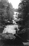
Over millions of years, the unique geological formation of the Blue Ridge Escarpment has sculpted a landscape of wonder and enchantment, including gorges carved by the many rivers and streams, an unusually large number of waterfalls that tumble over the massive rocky cliffs, and varied fragile ecosystems teeming with life.
To the east is the Chattooga River, famous for its rapids, which was designated a Wild and Scenic River in 1974. West of the Chattooga lies the Sumter National Forest, managed by the U.S. Forest Service. This area includes land from the Tugaloo Dam and lake on the south end of the Chattooga with Lake Hartwell and the Savannah River to the south, and north to the Ellicott Rock Wilderness at the North Carolina border, the river's headwaters.
Cherokee once lived in these mountains and forests, a history reflected in place names and legends, such as the Isaqueena Falls and Trail.
While the land generally was held as sacred by the Cherokee, certain spots held great power for them. Table Rock, its stark mass of granite rising from the forest floor, was believed to have been the actual table from which the gods took their meals.
The Blue Ridge escarpment, with its network of state parks and protected lands, is a major destination for hikers, botanists, water sports enthusiasts, rock climbers and other explorers. The Foothills Trail and a mesh of other hiking paths maintained by the state parks and other owners provide primitive camping and a variety of wilderness experiences for adventurers.
I find myself returning again and again to the magic of the place. There is something spiritual about this wilderness and the efforts to preserve it. As a writer not given to sentimentality, I'm trying to stick with the facts. But, undeniably, there is the magic factor, something of which the natives of this region, past and present, seem to have an inherent knowledge.
Dave Horner is a Greenville-based freelance writer.

© Copyright by POINT, 1995
Last modified 8/8/95
